The Megisti Map is more than a navigation aid; it’s an invitation to explore the hidden corners of Kastellorizo Chora, Greece’s southernmost island. With its winding streets, ancient fortifications, and crystal‑clear waters, the map reveals layers of history and culture that often go unnoticed by casual tourists.
We suggest for your stay:


Still Looking for the Perfect Stay?

Why the Megisti Map Matters
Historical Accuracy: The map incorporates centuries of cartographic research, highlighting landmarks such as the 15th‑century Venetian fortress and the medieval church of Saint George.
Modern Convenience: Integrated GPS coordinates allow visitors to pinpoint cafés, tavernas, and scenic viewpoints with ease.
Cultural Insight: Legends etched into the map’s margins tell stories of pirates, smugglers, and local folklore that enrich every walk through the town.
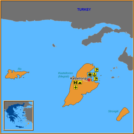
Key Attractions in Kastellorizo Chora
Venetian Castle (Castello) – Perched on a hilltop, this fortress offers panoramic views of the Aegean Sea. The Megisti Map marks its exact entrance points and the best times to visit for sunset photography.
St. George’s Church – A 13th‑century basilica with exquisite frescoes. The map notes nearby walking routes that avoid peak tourist crowds.
The Old Harbor – Where local fishermen bring in their daily catch. The map highlights the best spots to sit on the pier and watch the sunrise over the sea.
Local Markets – Small stalls selling handmade lace, olive oil, and fresh fish. The map’s color‑coded paths guide you through the maze of alleys where these markets thrive.

Nearby Islands Worth Visiting
While Kastellorizo Chora is a treasure in itself, the surrounding waters offer additional gems that are easily accessible:
Kastelorizo Public Airport – Located just outside the town center, this small airstrip connects the island to mainland Greece and nearby islands. The Megisti Map shows the quickest routes from the airport to major attractions.
Strongili Island – A short boat ride away, Strongili is famed for its untouched beaches and clear waters. The map provides recommended ferry schedules and hidden coves ideal for snorkeling.
Ro Island (Kastellorizo’s sister island) – Known as a quiet refuge, Ro offers secluded hiking trails that lead to ancient ruins. The Megisti Map marks the best trailheads and viewpoints overlooking the Aegean.
How to Use the Megisti Map Effectively
Download or Print: The map is available in high‑resolution PDF format for online use or can be printed on durable paper for field navigation.
Plan Your Route: Before heading out, identify key landmarks and note their coordinates. This helps avoid getting lost in the labyrinthine streets of Chora.
Explore Off‑Peak Hours: Use the map’s time‑of‑day suggestions to visit popular spots during quieter periods, ensuring a more intimate experience.
Combine with Local Guides: Pair the map with a local tour guide for deeper historical context and insider tips on hidden cafés or secret viewpoints.
Final Thoughts
The Megisti Map transforms Kastellorizo Chora from a simple tourist destination into an interactive adventure. By blending historical depth with modern navigation, it invites travelers to uncover the island’s hidden gems—from ancient fortresses to secluded coves—and to experience the true spirit of this Aegean jewel.
Ready to Explore?
Grab your copy of the Megisti Map today and start charting your own path through Kastellorizo Chora. Whether you’re a history buff, a nature lover, or simply seeking a peaceful escape, the map will guide you to unforgettable moments on this enchanting island.